 Lýsigagnagátt
Land Cover
Type of resources
Available actions
Topics
Keywords
Contact for the resource
Provided by
Formats
Representation types
Update frequencies
status
-

Riparian zones represent transitional areas occurring between land and freshwater ecosystems, characterised by distinctive hydrology, soil and biotic conditions and strongly influenced by the stream water. They provide a wide range of riparian functions (e.g. chemical filtration, flood control, bank stabilization, aquatic life and riparian wildlife support, etc.) and ecosystem services. The Riparian Zones products will support the objectives of several European legal acts and policy initiatives, such as the EU Biodiversity Strategy to 2020, the Habitats and Birds Directives and the Water Framework Directive. Land Cover/Land Use (LC/LU) classification is tailored to the needs of biodiversity monitoring in a tailored buffer zone along large and medium-sized European rivers (with Strahler levels 3-8 derived from EU-Hydro). LC/LU is extracted from VHR satellite data and other available data in a buffer zone of selected rivers. The classes follow the pre-defined nomenclature on the basis of MAES typology of ecosystems (Level 1 to Level 4) and Corine Land Cover, providing 80 distinct thematic classes with a Minimum Mapping Unit (MMU) of 0.5 ha and a Minimum Mapping Width (MMW) of 10 m. The production of the Riparian Zones products was coordinated by the European Environment Agency in the frame of the EU Copernicus programme.
-

The European Urban Atlas provides reliable, inter-comparable, high-resolution land use and land cover data for 800 Functional Urban Area (FUA) for the 2012 reference year in EEA39 countries. The spatial data can be downloaded together with a map for each FUA covered and a report with the metadata for the respective area. Additional information (product description, mapping guidance and class description) can be found here: https://land.copernicus.eu/user-corner/technical-library/urban-atlas-2012-mapping-guide-new Commission Directorate-General for Regional and Urban Policy and the Directorate-General for Enterprise and Industry in the frame of the EU Copernicus programme, with the support of the European Space Agency and the European Environment Agency.
-
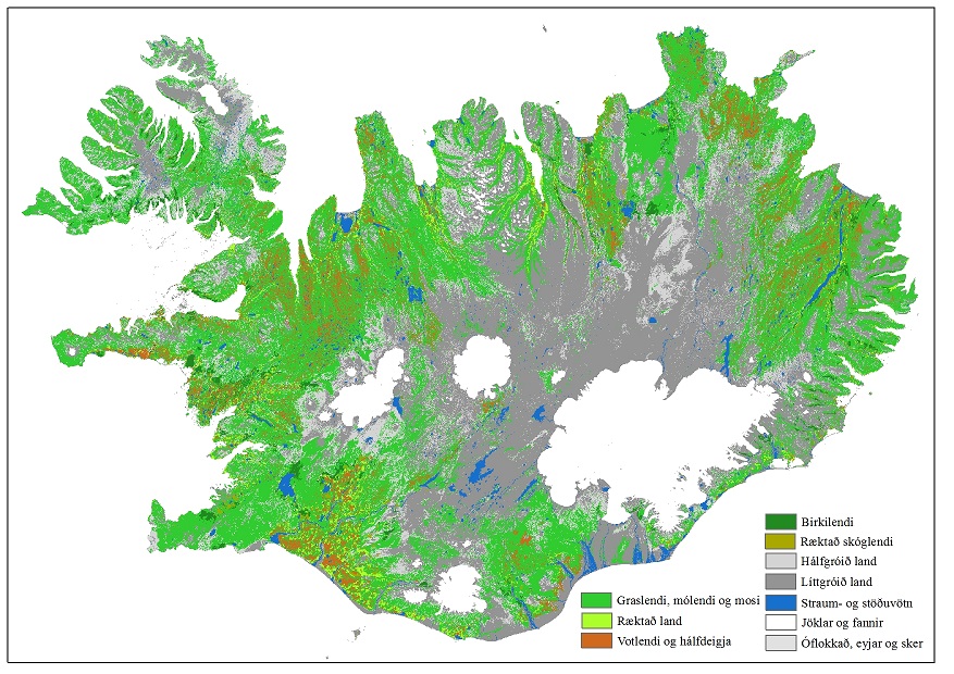
Nytjaland er verkefni sem miðaði að því að kortleggja yfirborð landsins, m.t.t. hversu grósku mikið það væri. Flokkunun var unnin með fjarkönnunaraðferðum á grunni Landsat 7 og SPOT 5 gervitunglamynda. Verkefnið var unnið á árunum 1999-2007. Var þá búið að gera yfirborðsflokkun á um 70% landsins í 12 flokka og 30% af yfirborðinu í 6 flokka. Nytjaland_N8 er einfölduð mynd af Nytjalandsgögnunum þar sem 12 flokka gögnin hafa verið aðlöguð að 6 flokka gögnunum. Flokkarnir graslendi, mólendi, rýrt mólendi og mosi (úr 12 flokka gögnunum) voru sameinaðir í einn flokk „Graslendi“. Inn í flokkuðu myndina Nytjaland_N8 hefur verið bætt gögnum Skógræktar ríkisins (2013) um "Náttúrulegt birkilendi“ og „Ræktaðan skóg". Flokkurinn ræktað land var hnitaður inn af gervitunglamyndum og var settur í rastagrunninn. Ár, vötn, jöklar og strandlína var samræmt vatnafarsgrunni LMÍ 2013. Viðmiðunarmælikvarði 1:30000